Well, this is it. I highly doubt I will ever be as far from home - or anywhere generally so remote - as Aitutaki. To illustrate, here is a map of the Cook Islands, with the nearest commonly known (in terms of where exactly it is) reference point - Auckland, New Zealand:
Maybe most poignantly, the islands - or even their labels - aren't actually visible at this level of zoom. Zooming in reveals the Cooks, which are scattered over an area of the Pacific the size of Europe, but the land surface is about a sixth of London. In fact, it is impossible to zoom in any more without losing sight of some of the more remote islands in the group, namely Penrhyn (B) and Mangaia (A):
The so-called "northern group" of islands is so inaccessible to travellers (and pretty much everyone else) on account of their distance even from Rarotonga that they are practically unvisited. Apart from private yachts (intrepid travellers have apparently "hitchhiked" on these from Raro), the only way to get there is on cargo ships which go irregularly at best; flights go rarely and irregularly. Fortunately, Aitutaki is rather closer to Rarotonga (which is where the "Cook Islands" word shows up on google maps), right at the bottom of this map:
To be precise, it was about a 45-minute flight on one of these bad boys to get there.
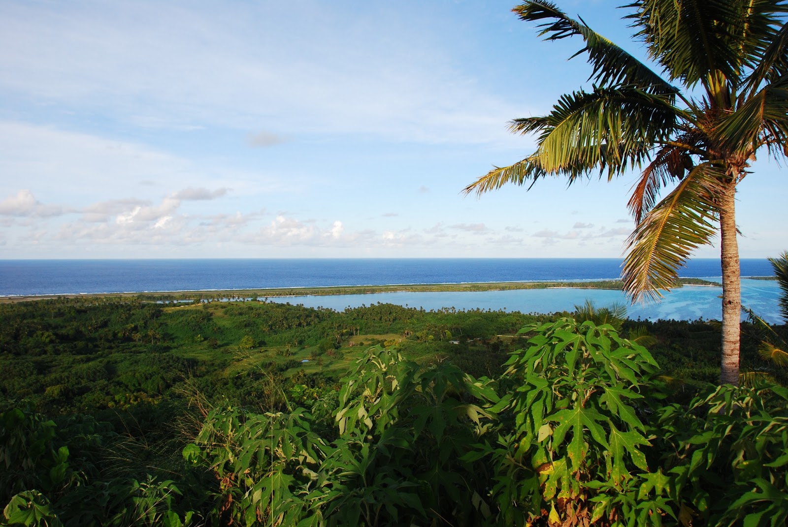
On the plane's approach my mind struggled to accept the fact that I was actually about to go somewhere as beautiful as what I was seeing. Since photos from a plane rarely do anything justice and I was sat on the wrong side anyway, here's one from the interwebs. The main (inhabited) island is the big one in the back, with the runway visible at the far end. The other motus, or islets, are uninhabited and sometimes little more than permanent sandbanks. They encircle a frankly out-of-this-world lagoon: when I explored the island on a scooter and found a hilltop vantage point, I just sat down for a good hour and a half and tried to drink it all in.


Now after having spent a few days on Raro I thought I had a rough grasp on islander lifestyle. I was about to be proven very, very wrong. It was a joy to see how uncorrupted Aitutaki is by tourism - a few luxury honeymoon-style resorts exist and provide employment, but the locals' lifestyle is completely unaffected by these. The resort guests rarely mingle, at most renting a scooter to zip around the island on their own, and the "cultural shows" serving clichés to flower-garland-wearing westerners are thankfully constrained to Rarotonga.
As you can imagine, then, I did not stay at a luxury resort. My home was the Paratrooper's Motel, an institution without a website which I only found out about from another hotel proprietor when I told her I couldn't afford her rooms.I stayed in a basic but spacious bungalow (2 rooms, all to myself!), effectively an outbuilding on a family's property near the main "village" of Arutanga. I hesitate to use the word village here because the only thing that distinguishes it from the rest of the island is that what few administrative buildings there are are mostly located in this general area.
Now my position - not unique, but rare among visitors of Aitutaki - of effectively living among the locals rather than in a segregated little bubble allowed me to experience fully just what friendliness means. With only 1000-odd inhabitants, everyone on the island knows each other (there are no addresses; the mailman simply knows where everyone lives). This means lots of waving, chatting, and general hanging out anytime two or more people cross paths. A far cry from London-style anonymity!
It also means that when an unknown face - like mine - shows up, people are curious and intrigued. On multiple occasions every day, whether I was on a bike, a scooter or on foot, people sitting in their front gardens taking a break from working (or not working - self-sufficiency is easy here, it seems!) would wave and call me over for a glass of water or some juice or ice cream, and for conversation. There was a lot of curiosity as to where I was from, what I was doing all the way out here, and, on the whole, smiles and good cheer absolutely everywhere.
In fact, it was impossible to just watch goings-on from a distance. During my days on Aitutaki, I watched a practice session of the island's boy scouts' brass band (I had stopped at the garden gates wondering what the music was when one of them saw me and called me over), went to a Sunday church service I was initially skeptical about (having never attended one before) and, after following the Henley Boat Races from 4 to 6am (time difference fun...), joined a bunch of revellers as they finished their last few drinks at the end of a long night. I also took a passport photo for a middle-aged woman who said she needed to get one to travel to New Zealand - her first time leaving the island!


Wherever I went, I was invited to join whatever was going on - it was great. In fact, the day following the post-HBR morning drinks, the same family invited me to dinner spontaneously: it was a Sunday evening, with lunch being the big meal (similar to an English roast). They offered me enormous quantities of taro, rice, coconut milk and the local specialty: raw tuna marinated in lemon, lime and spring onions. This is not dissimilar to sashimi but eaten in chunks rather than thin strips, and bursts with flavour from the marinade; absolutely delicious!
All that said, I did find one thing a little grating, or disappointing. Aitutaki was the first of the Cook Islands to be converted to Christianity in 1821, and every last Aitutakian is now a devout Christian. There isn't anything wrong with this, of course, but they did seem a little intense about it, using "God bless x or y" at every possibly opportunity - and putting up a LOT of signs along these lines:

Even this wouldn't really bother me much - each to their own, after all - but when I asked one of the island's high school (science) teachers why they were so comfortable with having left behind all of their old Polynesian culture (although not, fortunately, the language: everyone grows up fully bilingually) so completely, he couldn't, or didn't want to give me a straight answer. All I got was mumblings about "the Bible" and how everything was so much better now - and how the pre-Christian days had been "dark days". What I find sad and a little disturbing is that they see Christianity not as something different from Polynesian beliefs but something superior - and that they could not tell me why this would be so.
After all, the issue of young people leaving the islands for better money and job prospects in New Zealand is mostly caused by Christianty and the arrival of the Western notion that self-sufficient life was somehow not enough and that money and wealth should be striven for. I do not doubt that island life can be tough, but I have never seen people so universally content with their general situation. Yet, when confronted with this idea, I got no response apart from mutterings about "the Bible".
Eventually I let the issue rest as there seemed little reason to be argumentative - with these things there rarely is. Instead, it is time to turn to the other important aspect of Aitutaki - the fact that it is famous as one of the most beautiful islands/lagoons in the world.
It is not easy to put into words - or, for me, into photos - just how scenic the entire island is. Part of this stems from the untouched nature of it, with most of the few roads being unpaved, and from the complete absence of anything with more than one floor. But mostly, to be honest, it is simply the classic island paradise in its most ridiculously over-the-top form; no wonder people come here on their honeymoon - if this is your kind of honeymoon, then I cannot imagine anywhere better in the world.
My wider-ranging explorations were mostly undertaken on the one day I had a scooter, as the heat and humidity (and a rental bike on its very last legs) prevented me from getting around as far on most other days. They took me first to the southern tip of the main island, which is devoid of habitation and really just a track through empty jungle to, well, the other end of the island.

Once there, I had a little break for lunch and reading at a spot where I later attempted some good-luck photos for HBR (there was a BB one, as well...); I later completely failed to upload these due to the sketchy wifi connection...


Finally, it was time to hit the hills in the middle of the island, such as they are; the highest point is 123m above sea level. The view - yet again words fail me; I'm afraid these photos don't even come close to doing it justice. But hopefully they will convey something of just how I felt looking around.


I have to confess it made me quite happy that most of the houses up there, which boasted some incredible views (not least the two pictured above), belonged to locals rather than being holiday homes for rich New Zealanders. Another testament to how unspoilt this place really is.
In the evening, then, I tended to unwind from the day's strenuous activities with a book on the Pacific Resort's beach chairs. The resort being pretty empty at this point, nobody seemed to mind - and in fact, the whole beach was spectacularly empty for its whole length of at least a couple of miles:


And then, of course, there's the sunrise. And what a sunrise I was treated to - the next morning I sought out my hilltop spot from the previous day hoping for some nice colours on the water and in the sky.


Early on I suspected that this might be as good as it would get...I have rarely been gladder to have been horribly, horribly mistaken.


Righto - I think that's as close as I'm likely to do this incredible island justice. Having fallen behind with my blog in the lovely fortnight I spent in Japan with Helena, it is now catch-up time! Expect floods of photos from Japan, as well - being in a country (unlike, say, India) where running around with a DSLR is not just not unusual but, in fact, more common than running around without one, has contributed to my snap-happiness quite a lot.
Maybe most poignantly, the islands - or even their labels - aren't actually visible at this level of zoom. Zooming in reveals the Cooks, which are scattered over an area of the Pacific the size of Europe, but the land surface is about a sixth of London. In fact, it is impossible to zoom in any more without losing sight of some of the more remote islands in the group, namely Penrhyn (B) and Mangaia (A):
The so-called "northern group" of islands is so inaccessible to travellers (and pretty much everyone else) on account of their distance even from Rarotonga that they are practically unvisited. Apart from private yachts (intrepid travellers have apparently "hitchhiked" on these from Raro), the only way to get there is on cargo ships which go irregularly at best; flights go rarely and irregularly. Fortunately, Aitutaki is rather closer to Rarotonga (which is where the "Cook Islands" word shows up on google maps), right at the bottom of this map:
To be precise, it was about a 45-minute flight on one of these bad boys to get there.
 |
| A Saab 340, apparently. The flight attendant was one of three employed by Air Rarotonga (their other planes being too small to need a flight attendant), and she did the return flight to Aitutaki thrice a day. Fun times... |


 |
| This was the spot... |
As you can imagine, then, I did not stay at a luxury resort. My home was the Paratrooper's Motel, an institution without a website which I only found out about from another hotel proprietor when I told her I couldn't afford her rooms.I stayed in a basic but spacious bungalow (2 rooms, all to myself!), effectively an outbuilding on a family's property near the main "village" of Arutanga. I hesitate to use the word village here because the only thing that distinguishes it from the rest of the island is that what few administrative buildings there are are mostly located in this general area.
 |
| Arutanga City. |
 |
| Stark reminders of a tsunami 2 years ago which devastated 80% of the island's buildings. I chatted to an English woman who ran a crafts shop, and she said that despite having 4 children and a completely destroyed house weighing on her mind, the first thing her neighbour did afterwards was come by to see if *she* needed food. |
It also means that when an unknown face - like mine - shows up, people are curious and intrigued. On multiple occasions every day, whether I was on a bike, a scooter or on foot, people sitting in their front gardens taking a break from working (or not working - self-sufficiency is easy here, it seems!) would wave and call me over for a glass of water or some juice or ice cream, and for conversation. There was a lot of curiosity as to where I was from, what I was doing all the way out here, and, on the whole, smiles and good cheer absolutely everywhere.
In fact, it was impossible to just watch goings-on from a distance. During my days on Aitutaki, I watched a practice session of the island's boy scouts' brass band (I had stopped at the garden gates wondering what the music was when one of them saw me and called me over), went to a Sunday church service I was initially skeptical about (having never attended one before) and, after following the Henley Boat Races from 4 to 6am (time difference fun...), joined a bunch of revellers as they finished their last few drinks at the end of a long night. I also took a passport photo for a middle-aged woman who said she needed to get one to travel to New Zealand - her first time leaving the island!
 |
| Aitutaki's main church - there are several, including a Mormon church and a few other Christian denominations, but this is the oldest church in the Cook Islands. It dates back to 1821 and is made of coral, which makes for the blinding white of both church and graves. |


 |
| More impressions from the service - the preacher also ran the boy scouts' band, and he gave me a cheery wave when he spotted me mid-sermon. |
All that said, I did find one thing a little grating, or disappointing. Aitutaki was the first of the Cook Islands to be converted to Christianity in 1821, and every last Aitutakian is now a devout Christian. There isn't anything wrong with this, of course, but they did seem a little intense about it, using "God bless x or y" at every possibly opportunity - and putting up a LOT of signs along these lines:

 |
| Sadly, it felt like "their" tradition was rather thoroughly replaced about 200 years ago... |
After all, the issue of young people leaving the islands for better money and job prospects in New Zealand is mostly caused by Christianty and the arrival of the Western notion that self-sufficient life was somehow not enough and that money and wealth should be striven for. I do not doubt that island life can be tough, but I have never seen people so universally content with their general situation. Yet, when confronted with this idea, I got no response apart from mutterings about "the Bible".
Eventually I let the issue rest as there seemed little reason to be argumentative - with these things there rarely is. Instead, it is time to turn to the other important aspect of Aitutaki - the fact that it is famous as one of the most beautiful islands/lagoons in the world.
It is not easy to put into words - or, for me, into photos - just how scenic the entire island is. Part of this stems from the untouched nature of it, with most of the few roads being unpaved, and from the complete absence of anything with more than one floor. But mostly, to be honest, it is simply the classic island paradise in its most ridiculously over-the-top form; no wonder people come here on their honeymoon - if this is your kind of honeymoon, then I cannot imagine anywhere better in the world.
My wider-ranging explorations were mostly undertaken on the one day I had a scooter, as the heat and humidity (and a rental bike on its very last legs) prevented me from getting around as far on most other days. They took me first to the southern tip of the main island, which is devoid of habitation and really just a track through empty jungle to, well, the other end of the island.

Once there, I had a little break for lunch and reading at a spot where I later attempted some good-luck photos for HBR (there was a BB one, as well...); I later completely failed to upload these due to the sketchy wifi connection...


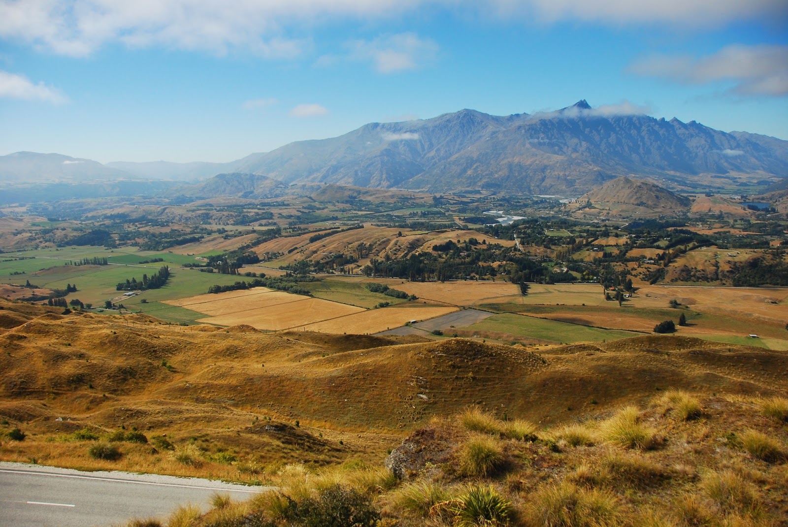
Finally, it was time to hit the hills in the middle of the island, such as they are; the highest point is 123m above sea level. The view - yet again words fail me; I'm afraid these photos don't even come close to doing it justice. But hopefully they will convey something of just how I felt looking around.


I have to confess it made me quite happy that most of the houses up there, which boasted some incredible views (not least the two pictured above), belonged to locals rather than being holiday homes for rich New Zealanders. Another testament to how unspoilt this place really is.
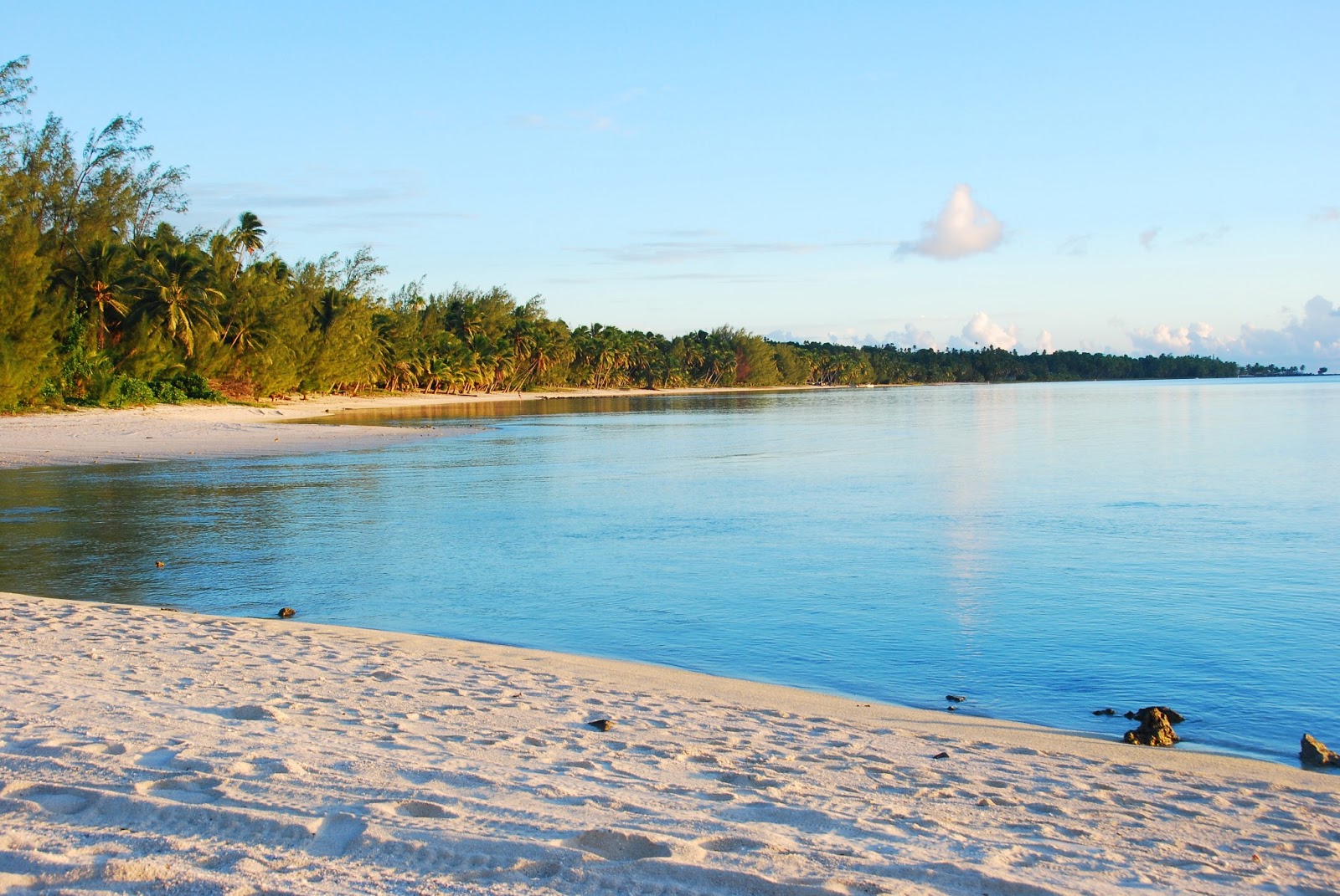
In the evening, then, I tended to unwind from the day's strenuous activities with a book on the Pacific Resort's beach chairs. The resort being pretty empty at this point, nobody seemed to mind - and in fact, the whole beach was spectacularly empty for its whole length of at least a couple of miles:

 |
| This cheeky crustacaean was the biggest of his kind I could find - by some way. |


Early on I suspected that this might be as good as it would get...I have rarely been gladder to have been horribly, horribly mistaken.


 |
| I really, really didn't want to cut down any further than this. May I be forgiven... |